
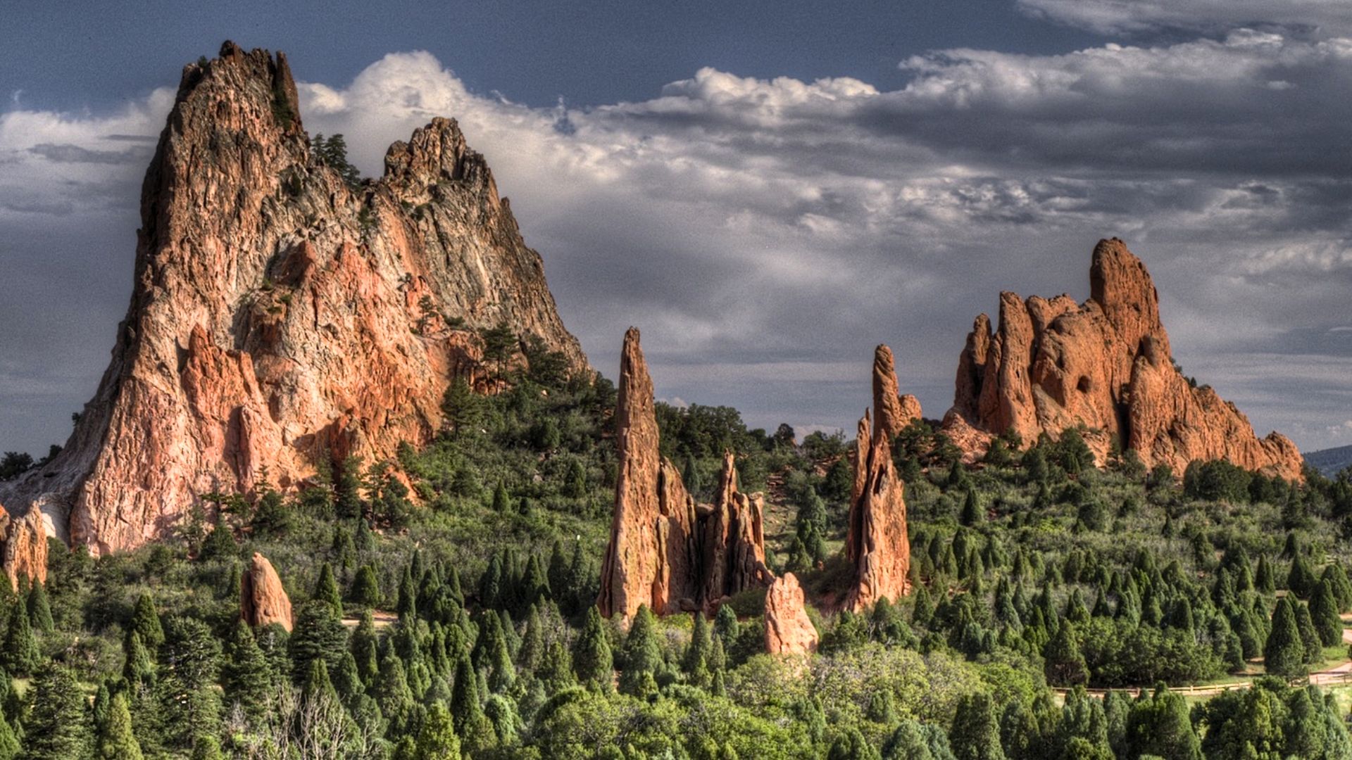
There is no rule that says a spectacular Colorado view must come with an entrance ticket. The state has mountain trails where red rock towers above a valley, foothills stretch toward snowy peaks and an ordinary afternoon can end with a view that looks expensive enough to have its own reservation desk.
The landscapes belong to public parks and open spaces, many of them accessible without paying to hike.
That doesn’t mean every part of the outing is automatically free. Parking can cost money near popular trailheads, some destinations require a free reservation, and mountain conditions can make a short route surprisingly demanding.
Read also: Locals line up early for warm cinnamon rolls at this family-run Minnesota cafe
The trick is choosing a trail that matches your experience and understanding the logistics before leaving home. These nine hikes offer an excellent starting point, ranging from gentle sandstone walks to lung-testing climbs.
1. Garden of the Gods Central Garden — Colorado Springs
- Distance: About 1.5 miles for a common Central Garden walk.
- Difficulty:
- Best season: Spring through fall, with winter walks possible when surfaces are safe.
- Parking: Free designated park lots, subject to capacity.

Credit: Garden of the Gods Park Visitor & Nature Center
The sight arrives almost immediately. Huge red sandstone formations rise from the landscape with Pikes Peak and the surrounding mountains creating a dramatic backdrop. You don’t need to climb for hours to understand why Garden of the Gods is one of Colorado’s most recognized places.
The paved Central Garden paths make the scenery accessible to many people who would not choose a difficult wilderness hike.
Read also: This Vermont farm stand has been selling fresh maple treats on the honor system for decades
Take time to look at the shapes rather than racing between photograph locations. Sunlight can change the color of the stone throughout the day, and a cloud moving over the mountain creates a completely different impression.
The city’s published park material confirms that entry is free. Several designated parking areas are also free, although crowded periods may require patience or a longer walk from an available lot.

Credit: Garden of the Gods Park Visitor & Nature Center
This is the best choice for a relaxed morning or for families who want scenery without a strenuous climb. Stay on the marked paths and resist the temptation to scramble onto formations for photographs.
The rocks are beautiful enough from the ground, and accidents can occur when visitors treat them like playground equipment.
2. Red Rock Canyon Open Space — Colorado Springs
- Distance: Approximately 2 to 3 miles for a selected mesa and canyon loop.
- Difficulty: Easy to moderate.
- Best season: Spring and fall.
- Parking: Two main park lots along West High Street; no ordinary hiking admission charge.
Read also: 7 Dirt-cheap day trips in Arizona you will want to take this winter

Credit: Friends of Red Rock Canyon (redrockcanyonopenspace.org)
Only a short distance from Garden of the Gods, Red Rock Canyon Open Space offers a quieter-feeling collection of trails beneath dramatic sandstone walls. The landscape carries traces of quarry history, and visitors can choose routes that vary from broad, comfortable paths to more uneven climbs.
It’s a place where the scenery rewards curiosity rather than one mandatory march to a summit.
One practical approach is to connect parts of the Mesa, Greenlee and canyon trail network according to the time you have. Distances depend on the route, so download the city’s current map before arriving. The most memorable view is the contrast between red rock, open foothills and the higher mountains beyond.

Credit: Friends of Red Rock Canyon (redrockcanyonopenspace.org)
In autumn, cooler weather makes the exposed sections particularly enjoyable.
Parking areas are reached from West High Street near Highway 24. Portable toilets are listed at the main lots, but carrying your own water remains sensible.
Read also: You might be surprised that one of America’s best pizza towns is this small Ohio city

Credit: Friends of Red Rock Canyon (redrockcanyonopenspace.org)
The city’s guidelines also distinguish pedestrian, bicycle and equestrian uses. Pay attention at intersections and yield as required. A free trail works best when everybody gives the shared space a little respect.
3. Paint Mines Interpretive Park — Calhan
- Distance: Up to about 4 miles across the trail network.
- Difficulty: Easy to moderate.
- Best season: Spring and fall.
- Parking: Designated main entrance lot; park entry is free.
The Paint Mines look almost as though somebody has been experimenting with colored chalk on a landscape. Layers of clay, unusual hoodoos and small gullies create a striking geological scene near Calhan, east of Colorado Springs. The county identifies roughly 750 acres and around four miles of trails, making it possible to choose a shorter outing without trying to see everything.

Credit: El Paso County
Read also: This hidden Washington waterfall is just a ten-minute walk from the parking lot
This is not the classic view of snowy summits behind a blue alpine lake. Its appeal lies in the unusual formations and the broad plains-and-mountain context of eastern Colorado. The colors can appear especially vivid in the softer light of morning or evening, although conditions and the sun’s angle will change what you see. Treat the formations as fragile. El Paso County specifically prohibits entering the formations, scrambling on them, or removing rocks and other material.

Credit: El Paso County
The park is free to enter and open from dawn to dusk. Dogs, horses and bicycles are prohibited, an important detail for visitors who routinely bring pets on hikes. Avoid the gullies in wet weather, when the clay can become slippery and erosion-sensitive. The best photograph is the one you can take from the permitted trail without damaging the very thing that brought you here.
4. Royal Arch — Boulder
- Distance: About 3.4 to 3.8 miles round trip, depending on route.
- Difficulty:
- Best season: Late spring through fall, with winter ice a concern.
- Parking: Chautauqua parking can be paid on summer weekends and holidays; the seasonal Park-to-Park shuttle has operated free.
Royal Arch makes visitors earn the view. From the Chautauqua area, the path climbs into the Flatirons landscape, moving through forest and steep steps toward a striking rock arch. It is a compact hike on paper, but the elevation gain and uneven sections can make it feel longer. Shoes with good grip and an honest assessment of fitness matter more than the relatively modest mileage.
Read also: 12 Michigan waterfront eateries worth a detour on your next summer drive
The reward is an impressive natural arch and views back toward Boulder and the plains. It feels almost theatrical when the rock suddenly appears, especially after the final strenuous stretch. This is a good morning hike for people who enjoy putting some effort between the parking lot and the photograph.

Credit: via Google Maps
The trail has no ordinary entrance fee, but the parking situation is not uniformly free. Boulder’s program charges for certain Chautauqua spaces on summer weekends and holidays, while a free seasonal shuttle has offered an alternative. Check the 2026 schedule and current municipal rules. If the whole purpose is a no-cost outing, plan the transport as carefully as the trail itself.
5. Spruce Mountain Open Space — Larkspur
- Distance: Approximately 5.5 to 5.6 miles for the full loop.
- Difficulty:
- Best season: Late spring through fall.
- Parking: County trailhead parking, with no general trail admission fee indicated.
Spruce Mountain offers a different kind of Colorado view. Instead of climbing into a high alpine basin, hikers follow a route through pine and fir to a rocky mesa-like summit area. The county’s published trail map describes switchbacks leading toward overlooks before the path loops around the top. It’s a satisfying choice for people who want a substantial walk without the exposure of a fourteener.

Credit: via Google Maps
The landscape rewards patience. Woodland gives way to open views, with the surrounding Front Range country visible between stands of trees. Fall can be especially pleasant when the air cools and the light turns softer. The route is long enough to feel like an outing, yet it avoids some of the extreme altitude that makes higher mountain hikes difficult for visitors.
The main consideration is distance. Bring water and snacks even if the trail looks gentle on a map. County access hours generally run from one hour before sunrise to one hour after sunset, and there are rules for dogs and other uses. Check the trailhead map before setting off, because shortcuts and junctions can change the loop you ultimately complete.
6. Mount Sanitas — Boulder
- Distance: Roughly 3 miles for a popular summit loop.
- Difficulty:
- Best season: Spring and fall.
- Parking: Limited public trailhead and nearby street options; obey local signs and any restrictions.
Mount Sanitas rises directly above Boulder, providing a remarkable sense of how quickly city streets can turn into mountain trails. The hike is relatively short but steep, with rocky steps and sustained climbing that demand more effort than a flat three-mile walk. It is a classic example of Colorado distance being only half the story. Elevation gain matters.
Read also: Hungry drivers find biscuits and sausage gravy at this tiny Kentucky roadside kitchen
At the summit, the view opens toward Boulder, the plains and surrounding foothills. On a clear day, the sense of height is impressive even though the mountain is not among Colorado’s tallest. The walk also provides an interesting perspective on the city’s relationship with its outdoor landscape: houses and roads sit almost directly beneath rugged terrain.
There is no standard park admission charge for the route. Parking near popular access points can be limited, and travelers should avoid assuming an unmarked roadside space is legal. Check Boulder’s current trailhead information, pack water and expect exposed sections near the top. A sunrise outing can be beautiful, but rocky footing is easier to handle when there is enough light to see it.
7. Mount Falcon Park — Morrison
- Distance: Around 2 to 3 miles for a shorter west-side loop; longer approaches are available.
- Difficulty: Easy to moderate for the short option, strenuous for longer climbs.
- Best season: Spring and fall.
- Parking: Jefferson County Open Space trailheads generally provide public parking without an entrance charge.
Mount Falcon is the sort of place that proves a good view doesn’t always demand an alpine expedition. Located in the foothills west of Denver, the park has trails through open slopes and wooded areas, with views toward the Front Range and plains. Historic ruins and interpretive features add interest for people who enjoy more than scenery alone.
Read also: This South Carolina island has no chain restaurants and that’s exactly why visitors love it
Choose the trailhead carefully. A short route from the west side delivers a very different amount of climbing from a longer approach beginning lower on the mountain. That flexibility makes the park suitable for a range of hikers, but only when the route is selected deliberately. The view worth remembering is the broad meeting of foothills, open country and distant mountains.
Bring layers. Even on sunny autumn days, shade and wind can change how comfortable the outing feels. Stay on designated routes, keep dogs controlled and don’t shortcut fragile sections for a clearer photo. This is an attractive option for travelers staying near Denver who want a mountain feeling without driving far into the high country.
8. Section 16 — Colorado Springs
- Distance: Approximately 5 to 6 miles for the commonly used loop.
- Difficulty: Moderate to strenuous.
- Best season: Spring and fall.
- Parking: Use designated access for the Section 16 and adjacent open-space trail network; check current lot rules.
Section 16 brings a more rugged feel to the foothills near Colorado Springs. The trail climbs over uneven terrain, passes through forested sections and connects with the broader network near Red Rock Canyon Open Space. For hikers who want something tougher than a paved scenic walk, it offers a satisfying change of pace without requiring a national park ticket.
The attraction is the mix of rocky foothill terrain and changing views. Portions of the loop reveal surrounding peaks and lower valleys, while other sections feel tucked into the landscape. Fall temperatures are particularly appealing on the climbs, although dry conditions can make loose surfaces dusty and slick in their own way.
Because trail connections and access points can be confusing, carry a current map and confirm where you intend to park. A trail’s free admission does not excuse parking outside legal spaces. Give yourself enough daylight for the full loop, and remember that a route with several steep portions takes longer than mileage alone might suggest. This is a better choice for confident hikers than for a first outing after arriving from sea level.
9. The Manitou Incline — Manitou Springs
- Distance: Less than one mile up the Incline, with a longer return via Barr Trail; plan roughly 4 miles total.
- Difficulty:
- Best season: Late spring through fall in safe conditions.
- Parking: Common access lots charge fees; a free reservation is mandatory.
There is nothing subtle about the Manitou Incline. The former cable-car alignment rises on 2,768 steps, gaining nearly 2,000 vertical feet in less than a mile. The grade becomes astonishingly steep. It is not a casual scenic path or a place to test new hiking shoes. The views toward the surrounding mountains and city grow more impressive with every breathless section of the climb.
The trail itself can be used without an entrance charge, but a free reservation and signed waiver are required. That is an important distinction. The city also recommends paid parking at designated locations, including the Dillon Mobility Hub, with shuttle options for reaching the trail area. Anyone promising a completely free drive-up visit is skipping a meaningful cost.
Choose this outing only if your fitness and conditions make sense. Go early, carry water, leave plenty of time for the descent route and don’t attempt to race the stairs. Lightning, ice, dehydration and overexertion are real concerns. Many excellent Colorado hikes are genuinely relaxed. The Incline isn’t one of them, even though its view can be unforgettable.
The mountain safety rules that save the day
Colorado weather is changeable, and a sunny forecast near a city does not guarantee pleasant conditions on a ridge. In summer, afternoon thunderstorms make exposed summits especially hazardous. Start early and be willing to turn around. In colder months, snow and ice may cover trails that looked easy in an August photograph. A route doesn’t become safe simply because a park remains technically open.
Altitude is another consideration. Drink water, pace yourself and allow time to acclimatize if you have arrived from a lower elevation. Headache, nausea and unusual fatigue can indicate that your body is struggling with the thin air; don’t ignore worsening symptoms. Carry an offline map, basic first-aid supplies, adequate food, water, warm layers and a waterproof shell. Tell someone where you’re going on longer or more remote hikes.
Free access also carries a responsibility to protect the places making the trip worthwhile. Stay on marked paths, respect wildlife and follow rules about pets, bicycles and fragile rock formations. At the Paint Mines, for example, entering the formations is prohibited. At other sites, scrambling off trail can damage vegetation or create fall hazards. The most impressive view isn’t worth an avoidable injury.
Let the scenery determine the budget, not the other way around
If you want a relaxed morning, begin with Garden of the Gods or Paint Mines. For a more demanding climb close to a city, choose Royal Arch or Mount Sanitas. Spruce Mountain offers a longer walk without requiring a high summit. The Incline is a challenge in its own category and should never be mistaken for a normal family hike.
The unifying pleasure is that Colorado’s outdoor beauty extends far beyond its national park boundaries. Most of these paths cost nothing to enter, even though some nearby parking facilities charge and one trail requires a free reservation. Check those details, match the hike to your ability and leave room in the day for the mountains to surprise you. Spectacular scenery doesn’t always ask for an entrance fee. It does ask for preparation.


