
Some waterfalls make you earn the view with hours of climbing, muddy switchbacks and the kind of uphill struggle that leaves everyone silent for the last mile. Others seem almost determined to surprise you.
You park beside a forest road, follow a modest path through the trees and discover that all that rushing water has been waiting only a few minutes away. It feels almost unfair to the people who spend the entire morning hiking to a lesser view.
Southwest Washington has a waterfall that fits the second description beautifully.
Read also: 12 Michigan waterfront eateries worth a detour on your next summer drive
The trail is so short that visitors may spend more time taking photographs than walking. But there’s an important catch: the destination is easy to miss from the road, and the surrounding forest can be unforgiving if you wander away from the designated path looking for a better angle.
The little trail with the enormous reward
Panther Creek Falls lies in the Gifford Pinchot National Forest in southwest Washington, within the broader Columbia River Gorge region. Washington Trails Association describes the approach as approximately 0.16 miles round trip, with about 100 feet of elevation gain. That’s barely more than a stroll on paper, although the short path is not the same thing as a perfectly level sidewalk.

Credit: Forest Service via https: fs.usda.gov
Read also: Hungry drivers find biscuits and sausage gravy at this tiny Kentucky roadside kitchen
The trail begins across the road from a gravel parking turnout on Forest Road 65. There is no elaborate entrance complex or ticket booth. The route leads through forest toward a viewing deck, where the waterfall provides the main attraction.
For many visitors, the entire walk can fit comfortably into ten minutes, though footing, weather and individual mobility needs will change the pace.
The short distance is what makes the place so appealing. A waterfall visit doesn’t have to consume the entire day. Families traveling through the region can add a scenic stop without planning a major expedition. Photographers may spend far longer considering light and composition than they spend reaching the view.

Credit: Forest Service via https: fs.usda.gov
Read also: This South Carolina island has no chain restaurants and that’s exactly why visitors love it
Why the waterfall looks so dramatic
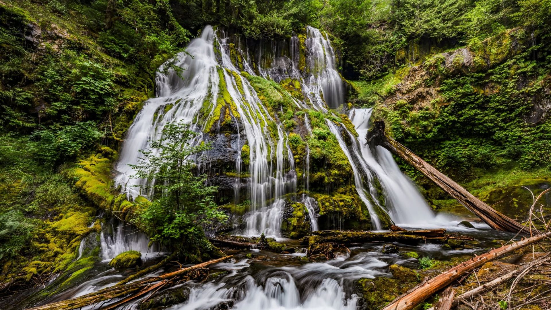
Panther Creek Falls isn’t memorable simply because of the amount of water moving downhill. Its form creates the spectacle. Water spreads and descends over a green, rocky slope, producing a layered, textured scene rather than one narrow ribbon dropping into a pool. Moss and vegetation soften the rock while the white water provides constant motion.

Credit: Washington Trails Association
That combination creates a striking contrast in photographs. Dark green surroundings frame the brighter water, and spray can bring a soft quality to the scene. The sound grows stronger as you approach the viewpoint. Even before the full waterfall is visible, moving water changes the atmosphere of the walk. A short trail can feel like a transition into a different world when traffic noise fades behind trees.
The experience also changes with conditions. Higher seasonal flow can make the cascade more forceful. Drier periods may reveal more of the underlying rock and the detailed paths taken by individual streams. Neither version needs dramatic exaggeration. It’s an interesting landscape because water, plants and stone are continually interacting in a confined space.

Credit: Wikipedia
The best season is not necessarily the sunniest one
Visitors often assume waterfalls are summer attractions, when roads are easier and days are long. That can be practical, particularly in forest areas affected by snow or seasonal road work. But waterfalls depend on water, and wetter parts of the year can produce more vigorous flow. In southwest Washington, spring and other wet periods can be especially rewarding when access is safe.
The trade-off is that conditions may be slippery. A gravel turnout, damp trail and moss-covered rocks can turn a tiny hike into a hazardous one if visitors aren’t paying attention. A bright summer day may be easier for a family, while a wetter season may reward a photographer who has planned carefully. The best choice depends on whether you prioritize comfort or a more forceful cascade.
Recent weather also matters more than the calendar alone. Heavy rain can affect roads, cause debris or change footing. Freezing temperatures may create ice. Before traveling, check the forecast and current forest road information. A short approach does not make a remote roadside site immune to closures or changing conditions.
The turnoff is the part that needs concentration
Washington Trails Association provides a route beginning in Carson. From there, follow Wind River Highway north for about four miles before turning onto Forest Road 65. The guidance then continues along the forest road toward Panther Creek Campground for approximately eight miles to a gravel turnout. The trailhead is across the road from that parking area.
This is a place where saving directions before you lose phone service is genuinely useful. WTA specifically warns that app-based navigation may be inaccurate in the area and data connections unreliable. Relying entirely on a changing blue dot is less sensible than downloading the route and looking for the described landmarks.
At the turnout, leave room for other drivers and do not block the roadway. Forest roads are working transport corridors as well as scenic access. A parking space that looks convenient may be dangerous if it forces another vehicle to maneuver around you on a narrow stretch. The waterfall will still be there after you’ve parked properly.
The viewpoint is where the story should happen
The established trail leads to a viewing deck. That is the place to enjoy the waterfall safely and with less damage to the surrounding forest. It offers a deliberate perspective on the cascade without requiring visitors to pick their way down steep, wet slopes. For many people, the best photograph is available right where the trail intends them to stand.
That can be difficult to accept in an age when social media rewards unusual angles. A photographer may look down toward the rocks and imagine a more dramatic shot closer to the water. But steep terrain, moss and spray make off-trail movement risky. The difference between a good photo and a serious fall can be one misplaced step.
Stay within established viewing areas. Don’t cross barriers or invent a route to the base because somebody once posted an image taken from an unsafe location. Protecting the setting is also part of the reason to remain on the trail. Vegetation on damp slopes can be fragile, and repeated shortcuts damage the very greenery that makes the waterfall so distinctive.
Why the hike is short but not effortless for everyone
A distance of 0.16 miles round trip sounds almost impossibly easy. For an experienced hiker, it may be. But WTA also notes roughly 100 feet of elevation change and identifies the path as a hiker-only trail. That makes footwear and personal mobility relevant. A short descent on uneven ground can feel more challenging than a longer walk on a paved town trail.
Visitors with limited mobility should review current accessibility information rather than assuming a viewing deck means the entire approach meets accessibility standards. There is no reliable basis for describing Panther Creek Falls as an ADA-accessible route. If a fully accessible waterfall outing is essential, compare other destinations that explicitly document accessible paths and facilities.
Families with young children should keep little ones close near slopes and wet surfaces. Dogs are permitted on leash according to the hiking guide, but a short leash may be easier to manage on a narrow path. Bringing a large picnic setup is unnecessary. Water, a light waterproof layer and sensible shoes are likely to be more useful than carrying a full backpack of equipment for a five-minute descent.
The no-fee detail is refreshingly straightforward
Washington Trails Association lists no parking pass or entrance fee for Panther Creek Falls. That makes the basic outing inexpensive, provided you can reach the trailhead safely. The larger cost is travel: fuel, time and the opportunity to explore the surrounding region. That’s an important distinction for visitors who may have driven quite far to reach what is technically a very short hike.
There is no grand visitor center with a ticket desk waiting at the trailhead. That simplicity can be charming, but it also means you need to be self-sufficient. Don’t count on staff to answer questions, sell water or help you find the parking turnout. Download directions, carry what you need and check official warnings before leaving populated areas.
Free access also comes with a responsibility to follow rules and respect closures. If a storm damages the trail or road, the absence of a gate fee doesn’t authorize visitors to pass around a closure sign. Conditions take priority over the original itinerary, even when the planned walk was only a few minutes long.
Another reason to check the latest alerts
The Gifford Pinchot National Forest is a large landscape with numerous roads, trails and seasonal restrictions. A general alert on the forest website may apply to a completely different part of the forest, so read the location and road numbers carefully. Conversely, the lack of a dramatic headline about Panther Creek Falls does not prove every access road is unobstructed on the morning you travel.
The supplied writing brief flagged significant trail and road concerns after a regional disaster. Current WTA information still lists the Panther Creek Falls trail, but a time-sensitive travel article should not infer real-time access from an evergreen hiking description. Check the Forest Service’s active alerts and WTA’s recent trip reports near your travel date. If there’s an unresolved access warning, postpone the visit rather than routing readers toward a possible closure.
This is one of those cases where responsible practical detail makes the story better. The waterfall is beautiful. The trail is short. Neither fact is diminished by an honest note that mountain and forest conditions can change quickly. A family with children will appreciate reliable warnings far more than a travel writer’s certainty about a road nobody has checked.
Getting the photograph without losing the experience
Waterfalls invite photographs, and Panther Creek’s layered shape makes it especially tempting to take several versions. A wide view can emphasize the full cascade and surrounding greenery. A tighter composition can concentrate on the patterned movement of water. Overcast light often reduces harsh contrast, although the exact results depend on weather and camera settings.
Try a few pictures and then put the device away for a moment. The sound is a large part of what makes the visit memorable, and a photograph cannot reproduce it. Listen to how the water fills the space. Notice the cooler, damper air near the viewpoint. Watch how individual streams separate and rejoin as they move over the slope. These are observations any visitor can make without claiming a fictional first-person experience.
If you’re using a camera on a tripod, be considerate of the narrow viewing area and other visitors. Nobody should have to edge toward a drop because one person has occupied the best position indefinitely. A little patience improves the experience for everyone, and the waterfall is unlikely to change its composition while you wait for someone else to finish.
Other short waterfall walks if plans change
The region offers alternatives, though they aren’t interchangeable with Panther Creek Falls. Lower Marble Creek Falls near Merwin Park has been described as a short accessible route to a smaller waterfall. Lucia Falls offers a riverside walk and views of moving water. Farther north, Whatcom Falls in Bellingham is famous for accessible park scenery. Each has its own driving distance, trail features and access rules.
These names are useful for people comparing options rather than a suggestion that all four can be visited on the same afternoon. Washington is a large state. A detour from the Columbia River area to Bellingham requires substantial driving, and what looks like a convenient alternative on a generic list may be nowhere near the route you are taking.
If Panther Creek’s access is affected by closure, choose another waterfall based on verified current conditions and the area you are actually visiting. There is no point replacing a ten-minute hike with a five-hour drive unless the bigger journey was already part of your plans.
A small forest stop can carry a big memory
Many people imagine a perfect waterfall outing as an ambitious hike ending at an enormous viewpoint. Panther Creek offers a different kind of reward. The physical approach is brief, the scenery feels richly layered and the cost of entry is zero. It is the kind of place that can slip naturally into a day built around other destinations.
But the short walk doesn’t excuse careless planning. Find the correct gravel turnout, cross the road carefully, stay on the designated trail and use the viewing deck. Check for seasonal road conditions and active closure notices. Bring shoes suited to damp ground rather than treating the route as an ordinary paved sidewalk.
Then give the waterfall a little time. You may reach the viewpoint in only a few minutes, but there is no rule saying you have to leave as quickly as you arrived. Sometimes a ten-minute walk deserves a much longer pause.


